Showing posts with label Prairie. Show all posts
Thursday, December 27, 2018
A Snapshot and The Scoop: Agate Fossil Beds
Sitting deep in an out of the way corner of western Nebraska, nestled between rolling sandhills and towering bluffs, lies Agate Fossil Beds National Monument. A quarry boasting bone and ash deposits from prehistoric times, Agate Fossil Beds was a stop along my dad's and my Father-Daughter trip this past winter. I somehow convinced Dad to make the walk along a windswept prairie path, passing over a baby Niobrara River, to the hills where the most concentration of fossils have been found. We were the only visitors around, so close to closing time, and we had the views and the trail all to ourselves. We took our time walking the paved path around the hills, searching for a hint of fossilized bone sticking out of the earth. We didn't see anything we recognized, but that's not to say there wasn't something right under our noses and we didn't know. It was a bit chilly, especially for me since my blood has thinned from living in the south for so long, and we didn't exactly spend hours outside. The walk was still nice, though, and the quite of the prairie around us reminded me why I like western Nebraksa.
Leave me a comment and tell me if you've ever been to this small National Monument. What did you think of it?
Sunday, December 16, 2018
Fifth Annual Father-Daughter Trip
Relaxed. Starting back in 2014, along with my desire to travel, my dad and I began taking Father-Daughter trips once a year. Sometimes we were accompanied by my sister and others, but at the core it was for us. Dad has a goal of visiting each of the five hundred plus historical markers in the state of Nebraska scattered throughout ninety-three counties, and every time we get a chance we hit the road on our quest to see them all. I thought maybe moving to Texas might mean the end of our travels, but I've been pleasantly surprised to find that's not the case. This past spring (ok, late winter in Nebraska) Dad and I took to the bluff country in extreme western Nebraska, searching for historical markers among the state's national monuments dedicated to the Great Western Trails.
Bluff country butts up agains the sandhills, and for anyone who thinks Nebraska is flat you're wrong. Well, partially wrong. Yes, Nebraska is flat if you keep to the I-80 corridor, but if you get off the interstate and head north you'll find a landscape of rolling prairie and sandstone bluffs that rise out of the grasses like the backs of giant sea creatures. The sandhills are my favorite place to visit in Nebraska, and I was more than happy to go with Dad as we scoured them for historical markers. Our quest brought us down some pretty obscure Nebraskan roads to some pretty obscure Nebraskan Monuments, but hey, "Honestly, it's not for everyone."
What's not for everyone? What about the fossil quarries laden with ice age bone and ash deposits at Agate Fossil Beds National Monument? What about the Oregon and California Trails that pass through the state's Scotts Bluff National Monument, rich with pioneering history? Don't get me wrong, I got out of Nebraska as soon as I had the chance because I always knew I would leave the state, but that doesn't mean I don't like to visit. And not just because my family is there. Nebraska boasts a neat assortment of state and historical parks, and a small handful of national monuments, that are well worth the effort of leaving the interstate to go explore. And that's exactly what Dad and I do every time we get a few days to run away to continue tracking down historical markers.
We might have cheated a little bit and drove up the 800 foot tall Scotts Bluff instead of hiking the trail to the top, but on a chilly winter/spring day, driving seemed like the more prudent option. The views of the prairie grasses and the ridge of bluffs receeding past the Wyoming border into the distance are something you wouldn't get if Nebraska really was flat, and I couldn't help but be a little awed at what lay around us. As the gateway to the more rugged mountain country in Wyoming, western Nebraska was a stop for many on the pioneer trails as they prepared for mountain conditions, and as such their trails, camps, and forts litter the area around the bluffs. The bluffs themselves were used as landmarks, breaking up the monotony of the plains.
One such landmark, a rather famous one if you were raised in Nebraska, is Chimney Rock. In my experince with my travels just about every state has a "Chimney Rock", but there is only one true rendition of this rock, and it resides in western Nebraksa. Dad's and my fifth Father-Daughter trip wouldn't have been complete without a stop at the state historical park protecting Chimney Rock, as well as no less than four historical markers near its location. Chimney Rock wasn't our last marker on our trip, but Dad and I began heading home after our visit to the park. I think we only have two or three areas of historical markers left to get, and then we'll have to find something else to do for our annual trips!
Labels:
Family,
Historical,
Musings,
National Monument,
Nebraska,
Plains,
Prairie,
Roads,
Winter
Location:
Scotts Bluff County, NE, USA
Tuesday, November 6, 2018
A Snapshot and The Scoop: Scotts Bluff
Scotts Bluff National Monument is one of several historically significant monuments in Nebraska. The park's namesake bluff towers 800 feet above the surrounding plains and was one of the landmarks used to navigate pioneering trails such as the Oregon Trail, the California Trail, and the Mormon Trail, all of which passed through the area on their way west. The history of Scotts Bluff is a bit morbid; it is named after a gentleman who was abandoned near its base after an illness made it impossible for him to travel and he subsequently starved to death. The bluff itself is a vision of whitish sandstone, volcanic ash, and clay, that pops against its surroundings. It is no wonder why the pioneers considered the bluff the gateway into the more rugged mountain country just to the west.
Thursday, November 1, 2018
A Snapshot and The Scoop: The Great Western Trails
It isn't often that you get to literally walk in the footsteps (or in this case wagon ruts) of the pioneers, but that is exactly what my dad and I did this year on a trip to western Nebraska. Our travels (1000 miles in 36 hours!!) took us along the same path as the pioneers, where we saw the same landmarks that traced their trails, and at Scotts Bluff National Monument we even walked the rutted path the wagon trains made on their journey west. Can you just imagine what it was like to house all of your worldly possessions in a covered wagon, hoping for a better life - at whoever's definition - on the other side of the country?
Also, side note: Happy Blog-iversary!! I've been writing this blog(sporadically lately, but still) for four years!! Much love to you all for following along as I go from one adventure to the next. Here's to many more years of travelling and sharing to come!
Thursday, October 25, 2018
A Snapshot and The Scoop: Dancing with Cranes
Have you ever come across somthing, either reading or hearing about it, especially something you didn't know about or hadn't thought about in a long time, then all of a sudden find yourself looking at it? This happened to me on a springtime visit to Nebraska. I had just been reading an article about the Sandhill Crane migration that cuts through the middle of the state, and then the next day I found myself unintentionally in the midst of thousands of the birds! I'm not sure if it was irony or dumb luck, or a combination, but my dad and I spent a good 45 minutes driving backroads, bird watching. Regardless, it was super neat to witness and brought back fond childhood memories of visiting the migration with my family. Fun stuff!
Labels:
Encounters,
Musings,
Nebraska,
Plains,
Prairie
Location:
Grand Island, NE, USA
Tuesday, October 2, 2018
A Snapshot and The Scoop: Chimney Rock
I know my Nebraska readers will know about Chimney Rock, but it is possible those from other states will know about this iconic landmark on the Oregon Trail, the great overland wagon trail in use during the pioneering days of our country. Dad and I stopped at the landmark on a trip to western Nebraska and we could practically feel the history of the area in the air. Dad and I like to travel to historically significant areas in the state, and as a National Historic Landmark we could hardly pass it up. We also couldn't miss it, as we could see the chimney while still many miles away from it.
Leave me a comment below and tell me if you've ever seen Chimney Rock before!
Thursday, December 14, 2017
A Snapshot and The Scoop: McBride Canyon
Have you ever started something and realized pretty quickly that it maybe wasn't the best idea? That happened to me when I visited McBride Canyon at Lake Meredith National Recreation Area. I descended down into the canyon and saw the pavement change into dirt. Cool, right? Then more dirt roads started branching off of mine, until I realized I would likely end up lost on those roads without a map, or else I would spend a lot more time in the wide canyon than I wanted to when I was on my way to Colorado already. I turned around the first chance I got, but I would love to go back someday when I do have more time to go exploring. I would love to camp down there!
Leave me a comment and tell me about a time you realized something wasn't smart. I know I'm not the only one!
Tuesday, December 12, 2017
A Snapshot and The Scoop: The Flint Quarries
I made a pit stop at Alibates Flint Quarries National Monument on my way to Colorado this August, just to check it out. The national monument has always been close to the route I take to leave Texas when I travel west, but I've never stopped. I decided to check it off my list and see what it was all about. I didn't stay too long, but I visited the museum and visitors center and learned how the ancient people who occupied the area mined flint for tools and trade from the rocks that is so close to the surface. I saw examples of tools found in the area, from knives to scrappers to arrowheads, and also a representation of what a quarry would look like. I didn't take one of the ranger-guided tours due to time restraints, but I did drive the short park roads before leaving. Next time I'll take a tour!
Leave me a comment below and tell me if you've ever heard of this small national monument in the panhandle of Texas!
Thursday, November 2, 2017
A Snapshot and The Scoop: The Geographical Center of North America
On our cross-country drive this past June Jared and I found oureslves at the geographical center of North America. How exactly they (whoever "they" is) calculated the centerpoint of Mexico, the U.S., and Canada, I have no idea, but when I saw the road sign for it I knew we had to stop. Its little attractions like this that make me love driving so much. Yes, I have a destination, but getting there is at least half of the fun. Also: bragging rights to being at the center of a continent!
Leave me a comment below and tell me if you've ever been here, or someplace similar. What roadside attractions do you like best?
Labels:
Historical,
Musings,
North Dakota,
Plains,
Prairie,
Roads
Location:
Rugby, ND 58368, USA
Tuesday, October 31, 2017
A Snapshot and The Scoop: White Petrified Wood
I've seen my fair share of petrified wood, and in every case the rock is incredibly colorful. On our trip to North Dakota this June, Jared, his grandma, one of his aunts, and I checked out Fort Stevenson State Park where we came across bone-white petrified wood. I've never seen it so white before! I went inside to ask the girl behind the museum counter about it, why it is white, but she had no idea. Unless maybe it was fake, but I doubt it. Now I need to find out what makes colorful petrified wood and what makes white petrified wood!
Leave me a comment below if you know what the difference it! I would love to learn!
Thursday, October 26, 2017
A Snapshot and The Scoop: Fort Stevenson State Park
Our trip up north this past June took Jared and I to visit family in North Dakota, where we also slipped in a visit to the local state park, Fort Stevenson. Located on the shore of Lake Sakakawea, Fort Stevenson is a gateway onto the lake but also holds its own as a historical park. The fort was used in the early days of trapping and exploring the wild west, and was a stop along the way to gold mines in Montana and Idaho, but today only a replica of the main building remains. It was still neat to learn about the history of the area and how things used to be for those who settled nearby. Its always fun to go to parks like this, to see how things had been.
Leave me a comment below and tell me if you think historical parks like this are neat, or are they boring?
Thursday, September 28, 2017
A Snapshot and The Scoop: Wupatki
I've visited this small national monument set on the edge of the vast Painted Desert between volcanic cinder hills and sweeping prairie before, but this time I got to take my history-buff sister! Alisha and I made a special trip to Wupatki on our way home from the Grand Canyon last May just because I knew how much she would love the history and culture of the monument, and I had to share it with her. The ancient culture who lived, farmed, hunted, and built homes in this arid land are admirable for many reasons, not least that they lived next to an active volcano not too far to the south. All that remains of these ancestoral people are pottery shards and crumbling stone buildings, but you can't help but imagine how their lives once were.
Leave me a comment below and tell me if you've ever visited Wupatki National Monument near Flagstaff, AZ. Would you?
Labels:
Arizona,
Desert,
Historical,
Mountains,
National Monument,
Plains,
Prairie,
Wupatki National Monument
Tuesday, September 26, 2017
A Snapshot and The Scoop: Earth Cracks
Have you ever heard of earth cracks? These small breaks in the earth's crust tend to form in earthquake-prone areas, such as near active volcanoes, where the earth literally splits apart. On our visit to Wupatki National Monument this May my sister and I saw several of these earth cracks, relics from a time when the San Francisco Mountains surrounding Flagstaff, AZ were volcanic peaks that pumped ash and magma into the surrounding area. The ancient cultures who lived near the volcanoes used the natural dams inside earth cracks to catch and store rainwater, and so their culture was able to survive in the semi-arid prairie not far from the mountains. Their ruins still stand on the rims of earth cracks all over the area protected by Wupatki, and the crumbling rock and adobe walls can make you feel small and insignificant when standing in the shadow of the past.
Leave me a comment below and tell me if you've ever heard of earth cracks. Have you seen some before?
Sunday, April 30, 2017
Taking a Break at Copper Breaks
Composed. I'm not often desperate for a break from work and life, but occasionally I find myself wishing I could escape for a while to recharge. I needed to do just that at the beginning of April, and had even made reservations at a state park in northwestern Texas to help me get away. Unfortunatley my weekend get-away was delayed by half a day, and I didn't head west until morning had passed. Starting a journey in the middle of the day is highly unusual for me, as I either start before dawn or after work in the evening, and as a result I reached Copper Breaks State Park in the early evening hours of a Saturday. I had intended to hike the majority of the day, then head to my backcountry site, but my late arrival forced me to go straight to camp and set up before the sun set and night descended.
My late start meant I arrived at camp after only a short hike, so I wasn't nearly as hungry or dirty as I usually am after a day of hiking. Instead of cleaning up and eating I had plenty of time to sit and watch the land grow golden in the evening light, then soften to deep greys as dusk fell. Coyotes started up as the sun dipped under the horizon, while Callie and I heard turkeys squabbling in the bushes below our camp. And the rabbits! Dozens of rabbits crawled out of their daytime hiding places and moved all around us on their way to their evening feasts. As we sat and watched night close in around us I couldn't help but take a deep breath and feel all of my stress melt away with the light.
While there was still light in the western sky Callie and I retired to the tent. I had left the fly off, knowing it there wasn't a chance of rain that night, so we could see the stars. I journaled while the sky deepened from velvet blue to black, and bright pinpricks sprang up in a spray above our heads. On the eastern horizon the moon rose above the plains of northwestern Texas and lit everything with its pale light. The rest of our night was filled with cool night breezes, an almost-full moon, and the echos of coyotes off of the little canyon walls all around us.
I slept deeper than I had in several weeks, and was still up before the sun. Callie was snuggled in the depths of the sleeping bag when I got up, but I was in no particular rush to start our day so I let her be. I crawled out of the tent and stretched, then pulled my sleeping pad out and settled in to a bit of sunrise yoga on the little platuea above the wash we had camped near, so I could see the sunrise. Long stretches and deep breaths, I all but melted into the ground. There was no wind, and the trees stood quitely nearby as the sky lightened and the clouds were shot through with pink and gold.
The sun had been up for quite a while before Callie and I finally got back on the trail. We first headed to the park headquarters to check in, then drove around the park for a bit to see what was there. Copper Breaks is a small, sparingly developed park located in the rolling plains of Texas near the Oklahoma border, and it wasn't busy. Definitely my kind of park. I chose a three mile long trail called Rocky Ledges to stretch our legs on before heading home, and Callie was just as excited as I was to get on a good dirt path. The trail wound around several small hills and gullies, taking us along an elevation about halfway between the bottom of the canyons and the top of the hills. At the point farthest from the parking lot the trail overlooked the Pease River and the swath of oak trees that line it. From there the trail descended steeply, but mellowed out as we approached our car. It was a nice little hike, and I can see myself going back for the solitude, if nothing else. I could use another night under the stars.
What I'm listening to: Flies and Spiders by Howard Shore
Thursday, March 23, 2017
A Snapshot and The Scoop: Cacti Galore
You all probably know by now that I love the moisture-loving fungi, mushrooms. On the drier side, though, there are the prickly plants known as cacti, and I love them just as much, if not more. Whenever I'm in an arid or semi-arid environment I always keep an eye out for the various cacti of the region, including the little barrel cacti pictured above. I even have a couple of cacti in pots at home, mostly because they're super easy to keep and care for. I especially look for the prickly pear cactus because their fruit is delicious, and whenever I get the chance to go back to the extreme southwest I intend to revisit the national park units named after cacti, Saguaro and Organ Pipe. For now, though, I'm content with seeing whatever is closer to home!
Sunday, October 16, 2016
A Sand Ramp, a Hang Bag, and a Little Blood
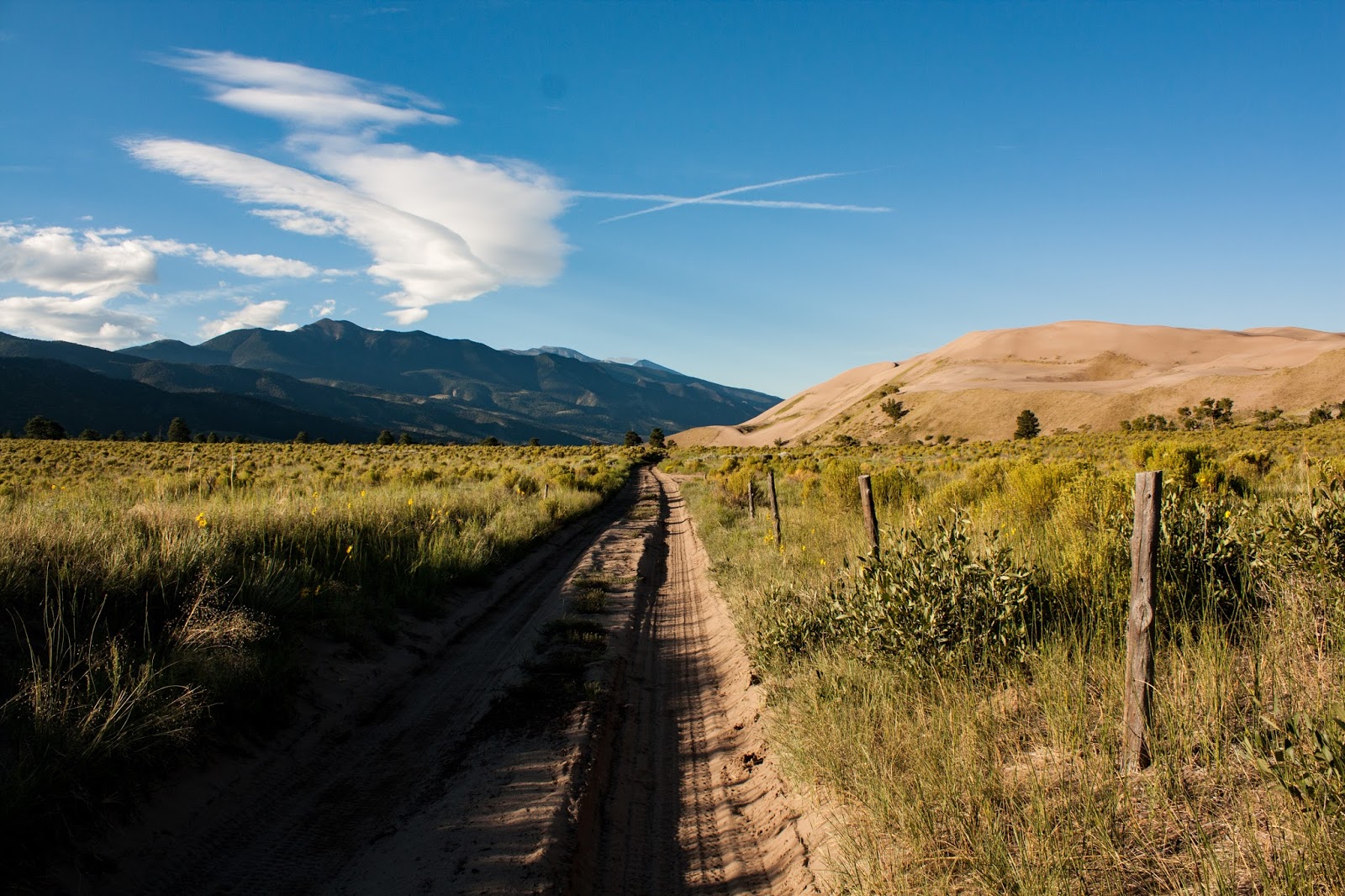
Contemplative. Our second night in the backcountry started off in a convenience store, where we picked up ramen noodles and a length of rope. For some reason (probably because I've never needed it before) rope was one of the few things missing from my extensive stash of camping gear, and the ramen noodles were a nod to our childhood memories. Torrey and I had hiked out of the dunes where we camped the night before, made a run to the closest place we could find rope and noodles, and headed back to the trailhead. We weren't in any sort of hurry, and enjoyed our noodles before swinging our packs onto our backs and setting off up the road. The trail to the preserve part of Great Sand Dunes National Park and Preserve runs across what is known as a sand ramp, a layer of sandy soil that lays between the dune field that can't support a lot of plant life and the mountains that house the majority of it. The sand ramp boasts green and yellow fields of prairie and desert plants, and trees start popping up the closer you get to the mountains. We technically needed to take the Sand Ramp Trail across the fields to reach our backcountry campsite, but knew we could walk along the 4-wheel drive road to the point where the trail crosses it, and catch the trail to our campsite from there. We figured the road would be a little more packed down and easier to walk on than the sand trail, which sees significantly less traffic and would exhaust us more. So up the road we went.
Even walking on the road wasn't easy, especially with a pack loaded with everything you need for an overnight miles away from civilization. We hiked more slowly than normal, both because we were slowed due to the soft sand and because we weren't really in a hurry. We had started mid-afternoon and only had 4.5 miles to go, so we really had all day. We kept an eye on the mountains, where the thunderstorms would start building, and an ear out for the sound of vehicles behind and before us as we hikes along the one-lane road. The mountains must have decided they had received enough rain over the past few days, and even though some clouds began to billow up, they never left the tops of the range. Trucks and SUVs passed us by occasionally, but we always had warning and stood off to the side to let them pass before we continued on. Eventually we came to a creek and pulled off our shoes to get across it. A couple of guys on dirt bikes who had passed us earlier were pulled off to the side near the creek, trying to get service on their phones. They called out to us as we approached, asking if we knew what the road was called and explaining that they couldn't get gps up to figure it out. I pulled out my map and showed them where we were, and told them what I remembered about the mountain road that climbs through the pass in the Sangre de Christo Mountains before us. They thanked us and turned around, apparently on the wrong road. Torrey and I crossed the icy creek slowly, careful not to slip over the slick rocks and sandy dips, before reaching the sand road on the other side and continuing on.
We didn't have to walk much farther on the road, and almost before we knew it we spotted the sign marking the place where the Sand Ramp Trail leaves the road and cuts deep into the preserve. We stopped there, wiping the sand off of our feet and putting our shoes back on in preparation for the steep hike before us. Until that point I had spent all week at significantly higher and drier elevations than what I'm used to from living in east Texas, and I had actually done really well. You might remember my story from last year's white water rafting trip about getting bloody noses a lot, for a time when I was younger, and they came back to plague me when I moved to Texas. Well, I had been doing great. I hadn't had a bloody nose in months, and hadn't had to deal with any all week in Colorado. That is, until I reached the trailhead to our final campsite and bent down to put my shoes on. I felt it coming and had about two seconds to slap my hand to my face before I started bleeding everywhere. I'm pretty sure I scared Torrey as I swore loudly and frantically asked for a tissue or anything. Since I'm me and I'm always prepared, I carry tissues in my pack and was able to have Torrey dig them out for me while I pinched my nose. Holy crap, it was a bad one. I'm pretty sure I bled for five minutes and soaked through countless tissues, which I carefully wrapped up in the plastic pocket of the empty tissue pack and stowed in my hipbelt. When it finally stopped, I had to use some of our precious water to wash my face, and had to ask Torrey to check me to make sure I didn't miss any blood.
Unfortunately, my bloody noses make me not feel very good for the first few minutes directly after, but we needed to hike on and still had about a mile to go over the soft sand trail, so I sucked it up and started walking. I was pretty quiet after that, trying to focus on the trail and not on how light-headed and slightly dizzy I was. The last mile dragged on forever, and it was with no small amount of relief that we finally reached the turnoff for our campsite. I immediately sat down on a log and just rested, drinking water and snacking on almonds until I felt better. Then we got to work and set the tent up, sorted our supplies and dinner, and made ready for a night in the wild. In the preserve you are required to either use a bear canister or hang your smellies, and since I don't have a bear canister (yet) we got rope and used the tent bag as our hang bag. I've never camped in a backcountry area with such a high population of bears, so I've never had to use a hang bag before, but it was kind of fun getting the rope over a branch so we could hang our food and trash nine feet up and five feet out. Plus, you know, we had the possiblity of seeing a bear! Once everything was in place we settled back in the tent and relaxed for a bit until we got hungry, then made dinner and explored our surroundings a little bit. We were treated to a gorgeous moonrise again, and spent a while walking in circles around our campsite just to see what we could find (and secretly looking for bear tracks, but we didn't find any.) We climbed back in to the tent at dusk, and called it a night. I can't speak for Torrey, but I slept soundly the entire night and didn't hear a single noise, not even coyotes or owls.
The next morning, when we were to head out of the park and go back to civilization on the Front Range in Manitou Springs, we were up at dawn and packing, preparing to hike out the way we hiked in. We reached the road and hiked up it for a while, until we heard the sound of a car approaching from behind. We stepped to the side and the driver, a NPS Ranger, stopped to chat with us and ended up offering us a ride back to our car. We gladly accepted, and I got to enjoy driving along a road that I can't wait to be able to drive myself. We chatted with the ranger, and he told us about how he does this job seasonally and is a ski guide during the winter. We talked about some of the other trails in the park, like the ones up the mountains to the headwaters of Medano Creek, and just made small talk as we rode the two miles back to our car. He dropped us off and wished us a good day and a fun trip, and went on his way. Torrey and I loaded up and followed after him, wishing ourselves that we didn't have to leave the dunes yet. Some day soon I want to spend an entire week backpacking there. Who wants to go with me?
Tuesday, August 23, 2016
A Snapshot and The Scoop: Prickly Pear Margaritas, Anyone?
I've made it no secret that I love cacti (they're so easy to take care of! Just plant them and leave them alone!) and that love extends beyond the ones in pots and gardens to whatever I find on my travels. I can't help but stop and take a few pictures of cacti along my desert trails, and when I saw this giant prickly pear cactu I couldn't resist. The bright yellow blooms stood out against the muted green "pear" stems of the plant, and where the fruit was ripening bright red flesh started to show. Mmhmmm, prickly pear chocolate.
Leave me a comment below and please tell me that I'm not the only one who likes cacti! Please?
Labels:
Canyon,
Caprock Canyons,
Cave,
Desert,
Plains,
Prairie,
State Park,
Texas
Thursday, August 18, 2016
A Snapshot and The Scoop: Fern Cave, an Oasis
If ever there was an oasis in the desert, this is it. Fern Cave is located at the end of a box canyon that is cut out a bit at the bottom, creating an alcove that just so happens to drip water year round. Ferns cling to the ceiling and the walls, and a stream dribbles down from the seep springs at the back of the cave. Callie and I found respite from the baking desert sun in the shade of the soft cave that smelled like green and water. We rested there for about twenty minutes, dipping my feet in the stream (and Callie full on laying in it), snacking, and cooling off. Then it was back into the oven of a canyon for about seven more miles to finish the trail.
Leave me a comment below and let me know if you've ever seen a prettier oasis!
Tuesday, August 16, 2016
A Snapshot and The Scoop: Kicking Back
Let me set the scene: My dog and I were in my car, pulled over on the side of the road watching a couple of bison grazing in the prairie above a lake. One of the bison ambled over, close to my car, and settled her girth on a bed of soft grass. All of a sudden she threw herself onto her side and started kicking up dust, writhing around on her back while throwing her legs up into the air. I was really confused and a little concerned at first (one of my dogs has seizures, so that's what my mind first jumped to) before I realized that she was taking a dust bath! It didn't last very long, then she clambered back to her feet, shook her whole body until a poof of dust rose above her, and went back to eating. And I was lucky enough to be in the right place at the right time to get photos of the whole process!
Leave me a comment below and let me know what you thought when you first saw the photo, without reading my story above.
Thursday, August 11, 2016
A Snapshot and The Scoop: I Could Watch For Hours
I don't care if some people think they're pests; prairie dogs are adorable! It may have something to do with me loving rodents (seriously, I love them) but I could sit in a prairie dog town for hours and just watch them. This bunch were busy foraging until I came along, then they stopped and watched me for a while until they decided I wasn't a threat and went back to their business. Also, did you know their towns are completely deserted on the surface until the sun comes up? Cute little buggers!
Leave me a comment below and tell me: Do you love prairie dogs or hate them?
Subscribe to:
Posts (Atom)