Tuesday, October 31, 2017

A Snapshot and The Scoop: White Petrified Wood


I've seen my fair share of petrified wood, and in every case the rock is incredibly colorful. On our trip to North Dakota this June, Jared, his grandma, one of his aunts, and I checked out Fort Stevenson State Park where we came across bone-white petrified wood. I've never seen it so white before! I went inside to ask the girl behind the museum counter about it, why it is white, but she had no idea. Unless maybe it was fake, but I doubt it. Now I need to find out what makes colorful petrified wood and what makes white petrified wood!

Leave me a comment below if you know what the difference it! I would love to learn!

Sunday, October 29, 2017

Rocky Mountain Adventures: Thunder Pass


Astounded. What in the world could possibly want to make two backpackers hike more? Well, for starters: better views. Also, if Torrey and I hadn't decided to hike Thunder Pass, almost on a whim, then we would have missed out on one of the most scenic hikes I've ever done. She and I had just made it to our second backpacking camp site of our week-long trip and had found it still occupied by the previous night's backpackers. Instead of waiting around for them to leave and making it awkward for everyone, we decided to stash our packs next to the trail and go for a short hike to the nearby mountain pass.


The hike took us across a wide meadow that we ended up camping by that night, then dove back into the forest for a bit before spitting us out at treeline. I'm pretty sure both of us stopped in amazement at what we faced when the trees broke apart: a cirque of green grass bowled out in front of us, full of little yellow and white wildflowers, while little stunted trees collectively called the krumholtz dotted the path up to the pass. A little brook was already babbling as it raced away from its snowfield source, growing stronger every few feet as seep springs bubbled up out of the grass to swell its waters.


The sun beat down on us in between fluffy white clouds moving across the sky, making us stop and apply sunscreen before continuing. We would roast alive if we tried to hike above treeline without protection. Here and there we spotted piles of bear feces, reminders that we were only frail visitors in their world, and nothing more. The trail to the pass wasn't exactly easy, and the more we climbed the more we gained in elevation, which really equals out to less oxygen and colder temperatures. That didn't stop us, though, because we were so determined to make it to the pass.


The hike wasn't just a joy hike, though it definitely was one of those too. No, Torrey and I had had Thunder Pass in our crosshairs since we knew we were going to be hiking so close, because Thunder Pass marks the northern boundary of Rocky Mountain National Park. We wanted to be able to say we had hiked over the park border, not just drove over it like the vast majority of visitors. Hiking up to Thunder Pass was bragging rights, in whatever twisted sense, and I definitely wanted to have that accomplishment under my belt. The beauty of the trail was a perk I had not expected, but gave a whole new purpose to our hike. After passing a few small alpine ponds and a snow field, we finally reached the pass and stopped short, staring at the tundra spread below us.


We overlooked a series of glacial tarns, threaded by a small silver river that splashed down cascade after cascade until it ran out of sight in the valley below our feet. The world on the other side of the park border was just as beautiful as the one we had just hiked up, and I was itching to continue on, wanting to explore farther. If we had been better prepared for a long hike, instead of the two miles to and from the pass, we might have gone on, leaving the pass and Rocky Mountain National Park to explore the valley below. Instead we turned to the west and climbed up a small hill that felt like a mountain, that we later discovered it wasn't named at all. From the top we looked back over the valley we had hiked the day before, dense with forest and hazy in the midday sun. Eventually we headed back down through the cirque to our camp site, but not before I promised myself I would hike beyond the pass one day, or perhapse hike up to the pass from outside the park. It is a place that definitely needs to be explored.


Want to read about the adventures we had to get to Thunder Pass? Read here, here, and here.

Thursday, October 26, 2017

A Snapshot and The Scoop: Fort Stevenson State Park


Our trip up north this past June took Jared and I to visit family in North Dakota, where we also slipped in a visit to the local state park, Fort Stevenson. Located on the shore of Lake Sakakawea, Fort Stevenson is a gateway onto the lake but also holds its own as a historical park. The fort was used in the early days of trapping and exploring the wild west, and was a stop along the way to gold mines in Montana and Idaho, but today only a replica of the main building remains. It was still neat to learn about the history of the area and how things used to be for those who settled nearby. Its always fun to go to parks like this, to see how things had been.

Leave me a comment below and tell me if you think historical parks like this are neat, or are they boring?

Tuesday, October 24, 2017

A Snapshot and The Scoop: Luna


I wrote a post about my worst fear while travelling being my car breaking down while in the middle of nowhere. While that is a big fear and something that should be of concern, I was wrong about it being my worst fear. My worst fear is losing one of my kids while I am a thousand or more miles away, with nothing I can do about it. My fear, my worst nightmare, came to pass when Jared and I were in North Dakota visiting family last June. Our lovely Luna, Jared's first pet on his own, our oldest girl, our sweet, crochety little old lady, grew very sick within a few days of us leaving home. She stopped eating, she became lethargic, and she lost energy. She was taken to the emergency clinic by our pet sitter and spent several days in the hospital on fluids, trying to support her and help her bounce back from whatever caused her to go downhill. She had been fine while we were home, but perhaps the stress of us leaving caused some internal problem that she had been hiding to rear its ugly head. Whatever happened, Luna did not get better. We had to make the call to let her go from more than a thousand miles away, by phone, unable to be there with her as she passed. I will never forgive myself for not being there with her, and I will always wonder, if we had come home would she still be with us? Losing a pet is never easy, and I've lost a few over the short time I've been a pet owner. Losing a pet while travelling is horrible, and the helplessness and powerlessness we felt in those awful days is something that I never want to experience again. Travelling always comes with risks, and that is something I have come to accept. I know that the more I travel, the less time I'm at home, the more bad things could happen, especially as our dogs and cats get older. I will still travel, and something happening to one of my pets while I'm gone has always been on my mind, but Luna's loss brings that fear into a sharper presence. Luna, we miss you.


Sunday, October 22, 2017

Rocky Mountain Adventures: Box Canyon


Comfortable. After a rather rough first day of hiking in Rocky Mountain National Park, I woke up in the backcountry at Skeleton Gulch camping area surrounded by mountains and forest feeling so much better. Torrey and I were not in a rush to do anything more than watch the mountains wake up around us, waiting for the sun to kiss our tent and banish the morning chill. We meandered down to our bear canister, positioned near a cheerful creek, and looked for any evidence of nightly visitors. We didn't see any, which relieved me more than I'd like to admit, and got to work on breakfast, fumbling with numb fingers over the locks on the bear canister before finally extracting what we needed to make oatmeal.


We truly weren't in a hurry but eventually found ourselves with our gear packed and ready to move on to our next site. We had a final chore before we left, needing to fill up our water bottles, which meant filtering water from the icy mountain stream near our camp. In hindsight we probably could have waited until the morning warmed up a little more, but I just wanted to get it over with, so I shoved my hand into the burning cold water so many times that near the end of it I almost lost the water filter, fumbling and shaking as I was. It slipped out of my hands and landed on a root right over the water, and I almost overbalanced as I lunged for it. Neither losing the filter nor me going into the water would have been a disaster, we would have been fine without it for the rest of the hike and I would have dried, but it wasn't the way I wanted to start my morning. Thankfully neither happened, and we finished filtering without another incident, though I gripped the filter a little more strongly than before.


Our next camp site, Box Canyon, was less than three miles away, but it required us to hike back down the way we came, including a portion of the incredibly steep trail. Going down something like that is always easier than climbing up, and the hike was mercifully short, including a brief walk on a dirt road that runs from the border of the park to deeper in. Once off the road we had a short but steep hike up to Box Canyon, but it went a thousand times better than the hike up to Skeleton Gulch, as short as it was. We arrived at our site to find the previous night's occupants still there, so we kept going and paused for a snack in the adjacent meadow before deciding to stash our packs and hike up to Thunder Pass. Thunder Pass is a story in itself and I'll write about it in my next full length post, but let me tell you right now that it has earned a spot on my list of top ten hiking trails. It was amazing!


Once we returned from Thunder Pass a couple hours later Box Canyon was empty and we set up, preparing for an afternoon of being off our feet. We made lunch, hung out by the creek, took a hundred photos, and watched as storms began to build and close in around us. We never went far from the tent and had plenty of time to get our gear stored away before it rained, and we watched as the single blue patch of sky directly above us grew smaller and smaller, eventually enclosing us under a blanket of grey.


We got lucky: the storms were still babies when they passed over us and we only got a few sprinkles. Further down the valley, back the way we had come, we listened to thunder echoing off the mountains to the south and east. Have you ever heard thunder echoing off the mountains? Its like drums talking to each other from either side of a valley, rolling in one direction, then coming from another. It was peaceful, sitting there in the warm, snug tent, listening to the storms bother somebody else. The storms and sounds would have been less cool if we were in the middle of them, and we didn't take that for granted, but it was still nice to have a calm evening. The temperature dropped with the storms as evening closed in and we got ready to settle down for the night, even though we knew the sun was still up and we had a couple hours of light left. Why move when you're comfy? Then, of course, when we were content with the world and our place in it, we had a visitor.


Did you miss the first two installments of my Rocky Mountain Adventure? Read them here and here, and don't forget to keep an eye on the Snapshots to read about our first of several wildlife encounters while in the back country. Preview: We didn't know what it was at first, just something huge right next to our tent!

Thursday, October 19, 2017

A Snapshot and The Scoop: Changing Boundaries


Petrified Forest National Park is an excellent example of the conservation of culturally significant lands being protected in stages as more research is done, land is surveyed, and the public voice is heard. What started out as a small piece of land preserving a tiny portion of an ancient forest turned to stone soon grew to include more of the forest, protecting it from looters and those intent on making a buck off of something that everyone should have a right to enjoy. Public lands are everyone's to enjoy and should be protected as such. The boundaries of Petrified Forest National Park grew in leaps and bounds, soon preserving not only the piece of desert viewable by car, but farther on, accessible to those who seek the solitude of a trail. It is things like this that a park should protect for everyone to to enjoy, not redact to help line someone's pocketbook or to prove a petty point.

Leave me a comment and tell me about another park that has expanded its boundaries since it was first designated. I can think of a few just in my lifetime, including Great Sand Dunes National Park and Preserve!

Tuesday, October 17, 2017

A Snapshot and The Scoop: Agate Bridge


The 110 foot ancient petrified log that is now Agate Bridge is part of Petrified Forest National Park, located in the Painted Desert of Arizona. This log was once part of a lush forest now preserved as colorful rock in an imitation of the wood it once was. The "bridge" was formed by water carving away the softer sandstone rock that lay underneath the log, and in the early days of the park a concrete support was placed underneath the log to help preserve the bridge. Their work is already fading away; water in the desert is a force to be reckoned with and will eventually cause the log to fall, making Agate Bridge no more.

Leave me a comment below and tell me if you've had the pleasure of seeing Agate Bridge. Have you visited this National Park?

Sunday, October 15, 2017

Rocky Mountain Adventures: Skeleton Gulch


Indisposed. Still riding the wave of excitement after watching the eclipse and seeing a moose, Torrey and I gathered our gear together and got to our first backcountry trailhead, where we planned to spend the next three days hiking and camping around the extreme northern edge of Rocky Mountain National Park. After a quick lunch where we tried to let the fact that we were finally actually doing this set in, we began! Our trail took us through a forest full of firs, spruce, and pines, winding along the baby Colorado River as it rushed from its headwaters towards the soaring red rock towers in the desert not far away. We kept an easy pace, trying to capitalize on the energy we were being fed from just being in the mountains again. It wasn't long before we came to our first check point at Lulu City, where a mining town once thrived. Now only the shell of a few log cabins remain, the rest reclaimed by the forest or torn apart by repurposing humans.


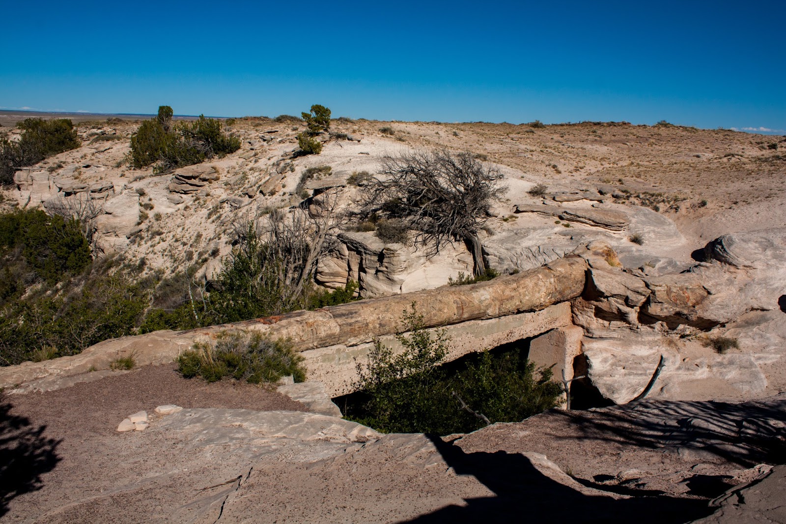
We crossed Colorado River over a log bridge not far after Lulu City, and it became obvious almost immediately that we were in for a tough hike. We were more than halfway to our first campsite at Skeleton Gulch, but the remainder of the trail was steep. Like, one wrong step and we would go tumbling back down the trail until we could stop ourselves or we hit the river. On most of the trails I've hiked this type of pitch is usally tackled by switchbacks. You know, those hated things that make you zigzag up a cliff or mountain or hill and make it seem like you're not gaining any ground but in reality they are helping you not have to take an incline head on. Yeah, this trail didn't have those. At most the trail curved around a giant boulder or a thick stand of trees, but that was about it. Every once in a while an erosion dam popped out of the earth in front of your feet, but that was about it as far as breaks went. I'll never bad-talk switchbacks again.


I used to pride myself on how well my body seemed to handle altitude. Growing up we would come to the mountains as a family often, just to get away for school breaks or long weekends, and I never felt the headaches or shortness of breath, the increased heart rate or the stomache cramps, those traits of altitude sickness. Last year when Torrey and I came up for Pike's Peak and our roadtrip around Colorado I really only got a headache, and that was at the very tippy top of a 14,000+ foot mountain. This year? A totally different story. Yes, I dealt with a little bit of altitude sickness at Pike's Peak, but I thought that would be the end of it, my body would adjust, and I'd be fine for the rest of the week. I was also very, very wrong. Our first day of hiking in the mountains, loaded down with a heavy pack and trying to make it up a steep incline, almost did me in. My stomach was cramping so bad I was hunching over, which made it even more difficult to breath because my pack straps were restricting my lung expansion. I was having to stop more and more frequently, and at some points I was nearly in tears. What the hell was wrong with me??


I was too sick to even be relieved when we finally made it to camp, but forced myself to pay attention to things like the slope of the camp area, dead trees above us, and other basic backcountry safety. I was already miserable enough without adding to my problems. Torrey and I set up, with me trying to move as little as possible, and made sure we followed the bear safety rules about putting your bear canister (required in the park) at least seventy steps or two hundred feet away from your camp area. I tried to walk around and take pictures of our camp, the stream, and the meadow next to us, but felt worse and worse the more I walked around. I was also shivering, although it wasn't all that cold, maybe in the 60s, and that in itself was enough to tell me that my body had had enough. I don't get cold that easily (I may live in Texas now, but remember I'm from Nebraska and I know what winter is) and when I start to shiver in nice weather its a good indication that something is wrong.


The sun had dipped behind the high mountains next to us, but hadn't set for the night yet, so I pulled on every single layer of clothing I had brought with me and tried to tough it out, wanting to relish the fact that we were finally back in the mountains even though I felt like shit. It wasn't long before I gave in, apologizing to Torrey and explaining that there was no way I would be able to keep dinner down, before burrowing into my sleeping bag and trying not to throw up all over the inside of our tent. At one point Torrey grabbed some medicine for me out of the bear canister and it helped a little bit, enough to send me floating off into sleep. Not long after, she joined me in the tent and as we settled in for the night we heard the distinctive cracking of branches down towards our bear canister. I was on the edge of a dream but Torrey's sudden stillness brought me sharply back to the present, and we heard it again. We had to ask each other if we had heard it, not wanting to admit fear of the unknown was making it up in our own heads, and a few minutes of intent listening convinced me it was the sound of hooves making their way towards the neighboring meadow. Nothing bothered us, anyway, and that was really all I cared about. I turned over and burrowed back down into my sleeping bag, hoping I would feel better in the morning as I drifted off to sleep.


Did you miss the first post of my Rocky Mountain Adventures? Read it here!

Thursday, October 12, 2017

A Snapshot and The Scoop: Farming the Desert


Getting anything to grow in a place with very little rainfall is hard enough, but getting enough to grow to feed a village must have been even more difficult. Somehow the ancient Native America cultures who lived in the arid southwest managed to do it, utilizing dry land farming techniques to grow enough to live. These techniques used the land they had, including slopes, rock dams, and occasional rains to cultivate corn, squash, beans, and other foods native to the region. Don't think of farming in the big scale that we use now; think small plots, no bigger than the size of a modern bathroom, carefully laid out in the best place possible to collect rain and to protect it from animals. The lengths people go to survive is amazing!

Leave me a comment below and tell me if you've seen dry land farming techniques like this before. Where?

Tuesday, October 10, 2017

A Snapshot and The Scoop: Walnut Canyon


Cliff dwellings! Cliff dwellings by the dozens! This small national monument just outside of Flagstaff, AZ has a huge collection of cliff dwellings, all located within the three arms of the semi-arid but high-altitude Walnut Canyon. The canyon used to flood often, bringing life-giving water to the ancient people who lived here, but dams upstream have reduced the flow of water to only seasonal bouts of trickling streams except after heavy rains. Now nothing but the remnants of an ancient way of life remain, visible by a short but steep hike into the canyon from the visitors center on the rim. Alisha and I were still healing after our epic Grand Canyon hike and could hardly put one foot in front of the other, let alone hike a steep canyon trail, so we skipped out on getting into the canyon proper. We view some of the dwellings from the rim with a promise to come back and see them up close next time we were in the area!

Leave me a comment below and tell me if you've ever heard of Walnut Canyon. History nerds only?

Sunday, October 8, 2017

Rocky Mountain Adventures: The Eclipse


Entranced. Yes, I'm one of those people who are going to write about the eclipse. No matter where you were in the United States you would have been able to see at least a partial eclipse (as long as you didn't have cloud cover), and if you were some of the thousands of people who flocked to the path of totality then you witnessed something incredibly, but you already know that. Torrey and I had just begun our 2017 Rocky Mountain Adventure, arriving at Rocky Mountain National Park Visitors Center on the west side of the park just in time to catch the beginning of the eclipse.


We grabbed our backpacking permits from the wilderness office there, then stuck around, hanging out with other visitors who were also viewing the eclipse, taking turns to peek through a neat solar telescope provided by rangers. We also had our own solar sunglasses, courtesy of Torrey's mom, that we could view the eclipse with safely. I've heard the horror stories of people who did not correctly protect their eyes during an eclipse, even a total eclipse, and I was not going to be one of them.


Light and shadows changed as the eclipse grew towards maximum coverage, which was 94% where we were in Rocky Mountain National Park, and we began noticing the eclipse reflected in the tree leaf shadows cast upon the pavement, or how you could see how far the moon had progressed if you laced your fingers together to make a checkerboard pattern on the ground. I remember viewing partial eclipses with my dad when I was younger, and though I didn't get to see a total eclipse this time around it was still something I won't forget.


At the peak of the eclipse the light dimmed, casting a glow that resembled what you get at dawn or dusk, but the shadows had a fuzzy quality to them, and instead of elongating they remained where they would be at almost noon. It just felt all wrong in the best way possible. The world returned to normal just as slowly as it had slipped out of sync, brightening the trees around us and casting deeper shadows with every passing minute.


And then we heard a shout from a few other visitors: a moose had snuck in to the parking lot while we were all staring up, and she was happily munching away on some leaves without a care that the world had just dimmed and brightened again. We scrambled over to take a look at her as she continued her grazing, and Torrey and I took her presence as a good sign for our blossoming adventures. We got to see an eclipse and a moose, all within the first hour of being in the park! We knew it was going to be a fantastic trip. We had no idea what we were in for.


Thursday, October 5, 2017

A Snapshot and The Scoop: Sunset Crater


This thousand-foot high cinder cone is just a baby in terms of geological time, coming to life with a roar and fountain of lava and dying after a few months or short years. Cinder cones like Sunset Crater Volcano are formed when a certain type of magma containing a lot of basalt becomes pressurized, spraying up into the air and cooling in little fragments as the pieces land back on earth. Sunset Crater is surrounded by lava fields and other small cinder hills as well, remnants of its short-lived explosions. It gets its name from the red color of the cinders at the rim, with early explorers and native americans variously naming the mountain "red hill", "burnt land", "yellow mountain" and "sunset mountain". Eventually the name Sunset Crater stuck, and now we know it as a national monument preserving one of the youngest extinct volcanoes in the U.S.

Leave me a comment below and tell me another name for Sunset Crater. What would you have called it?

Tuesday, October 3, 2017

A Snapshot and The Scoop: A Will to Live


Life truly will find a way to live. Did you know Ponderosa Pines will sprial in harsh conditions to help stablize their structure? I had no idea trees could do this, until I visited Sunset Crater Volcano National Monument and saw the skeletons of ponderosas blasted by the extinct volcano's most recent explosion, where the strips of exposed wood, devoid of bark, do indeed spiral up the trunk. The branches of the tree (what were left, anyway) sprialed and knotted as well, giving the tree a gnarled look that spoke of a tough will to live. The conditions of growing on an active volcano can't have been easy, but you have to give the trees props for trying. Even now, a thousand years later, only a few trees dot the cinder cone and the surrounding lava fields, sucking at the knife-sharp rocks to try to get a hold on the land. Someday the trees will win and life will return to the volcano.

Leave me a comment below and tell me if you knew trees could spiral. How neat!